Josaphat Microwave Remote Sensing Laboratory (JMRSL) or Josaphat Laboratory focuses on the education and research (software and hardware) on microwave remote sensors, including the synthetic aperture radar (SAR) for drones (unmanned aerial vehicles), stratosphere platforms, aircraft, and microsatellites, and also applications using microwave and optical sensors for disaster and environmental monitoring using Artificial Intelligent (AI), including weather / climate modification.
Unmanned Aerial Vehicles or Drones for Remote Sensing Applications
Josaphat Laboratory (JMRSL) developed an original unmanned aerial vehicle called Josaphat Laboratory Flight Experimental Unmanned Aerial Vehicle (JX series) for an operation altitude of four kilometers and payload of 25 kg. This drone could onboard the remote sensors and container for supporting the disaster prediction, in-time disaster, and disaster recovery period.


Synthetic Aperture Radar (SAR) for Middle Scaled Aircraft
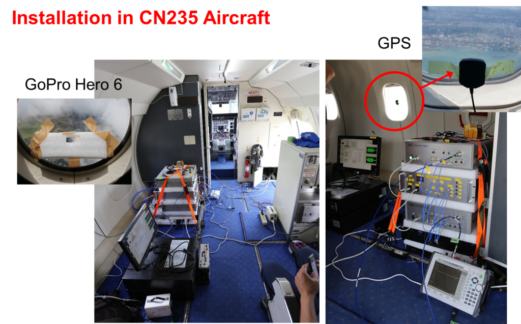
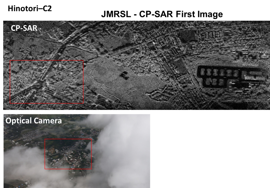
Josaphat Laboratory (JMRSL) develops various synthetic aperture radar (SAR) for middle-scale aircraft.

Synthetic Aperture Radar for Large-scaled Aircraft
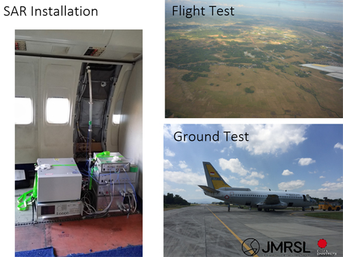
Josaphat Laboratory (JMRSL) developed synthetic aperture radar (SAR) for large-scaled aircraft.
Synthetic Aperture Radar (SAR) onboard Microsatellite
Josaphat Laboratory (JMRSL) developed synthetic aperture radar onboard microsatellite.

Weather / Climate Modification Simulator and Applications
Josaphat Laboratory develops the weather/climate modification simulator, system, and application to reduce the atmospheric disasters caused by typhoons (cyclones, tornados) and cloudseeding to modify the dry land to productive land.
Radar for Real-time Oil Leakage Observation in Offshore Drilling Facility
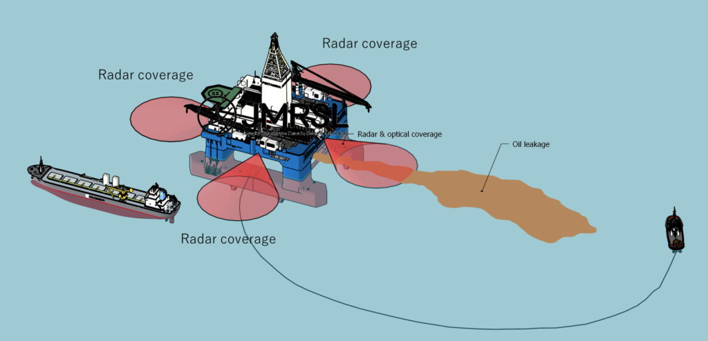
Josaphat Laboratory (JMRSL) develops several types of radar for real-time oil leakage observation in offshore drilling facilities.
Reconstruction of Ancient Environments using fossils, remote sensing, DNA, radiation methods, spatial AI, etc.
Josaphat Laboratory (JMRSL) is reconstructing the ancient environments using fossils, remote sensing, DNA, radiation methods, spatial AI, etc.

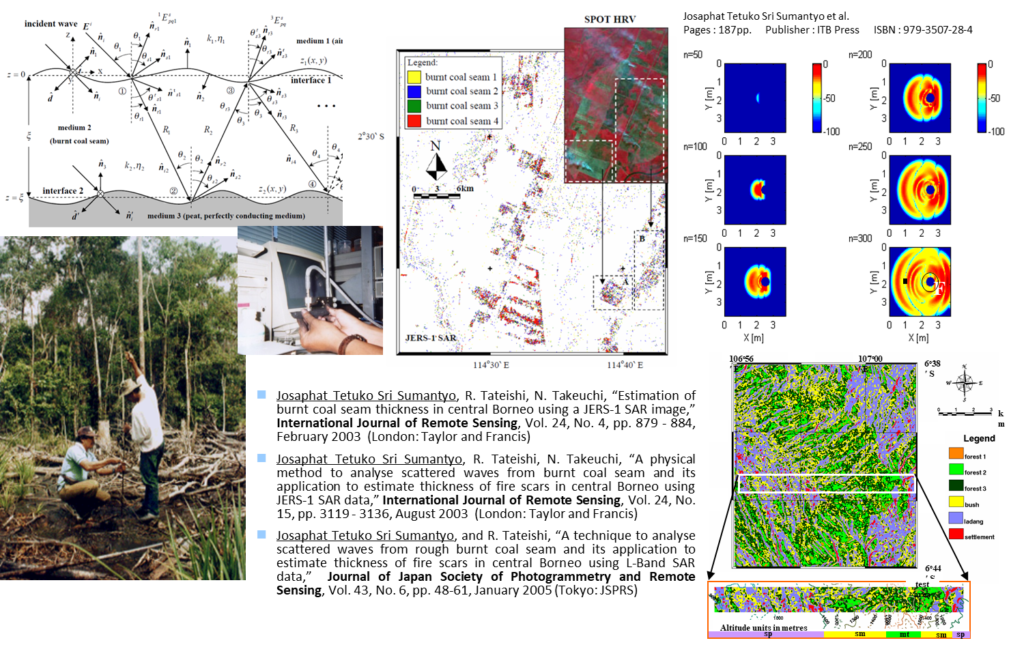
Application: Electromagnetic Scattering Problem and the Application for Burnt Coal Estimation
Josaphat Laboratory (JMRSL) developed our novel techniques to estimate underground objects, for example the peatland.
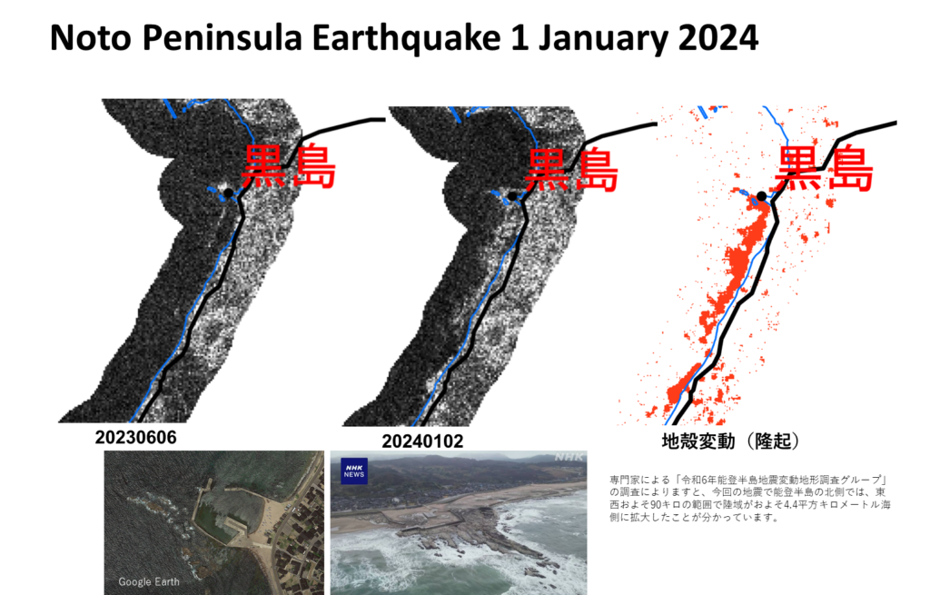
Application: Uplift in Earthquake Event
Josaphat Laboratory (JMRSL) developed various methods to determine the impact of disasters on the land surface and human activities. For example, the uplift caused by the Noto peninsula’s Earthquake on 1 January 2024.


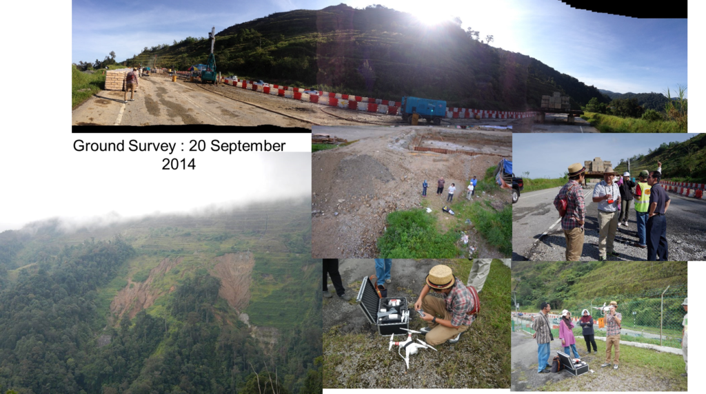
Application: Landslide Monitoring
Josaphat Laboratory (JMRSL) developed various techniques to observe the landslide and its impact on national infrastructure, i.e., highways, electricity networks, roads, railways, etc. For example, our project under the SATREPS Program (JICA and JST) was to monitor the landslide in the Malay peninsula from 2005 to 2010.

Application: Monitoring of Sedimentation at Coastal Cities
Josaphat Laboratory (JMRSL) developed various techniques to estimate land sedimentation and monitor coastal change and its impact.

Application: War Impact Assessment
Josaphat Laboratory (JMRSL) developed several methods to study the war impact assessment to estimate the damage to the human environment using remote sensing technology.


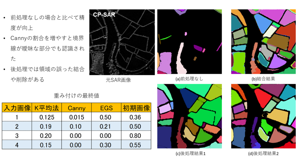
Application: Boundary Mapping using AI for Urban Monitoring
Josaphat Laboratory (JMRSL) developed some methods to mapping the land parcel using remote sensing technology.

Application: Turbulence Prediction for Air Traffic Safety
Josaphat Laboratory (JMRSL) developed various methods to predict turbulence for air traffic safety.

Several research studies are being conducted presently and will be published soon.
研究
Josaphat Microwave Remote Sensing Laboratory (JMRSL) またはヨサファット研究室は、ドローン (無人航空機)、成層圏プラットフォーム、航空機、小型衛星搭載用の合成開口レーダー (SAR) などのマイクロ波リモート センサーの教育・研究開発(ソフトウェアおよびハードウェア) に焦点を当てています。 マイクロ波および光センサーを使用した災害監視や、気象/気候変動を含む人工知能 (AI) を使用した環境監視などのアプリケーションの開発をしています。
リモートセンシングアプリケーション用の無人航空機またはドローン
ヨサファット研究所 (JMRSL) は、運用高度 4 キロメートル、ペイロード 25 kg のヨサファット研究所飛行実験用無人航空機 (JX シリーズ) と呼ばれるオリジナルの無人航空機を開発しました。このドローンはリモートセンサと救援用コンテナーを搭載可能で、災害の予測、災害時観測、復興支援のために使用できます。


中規模航空機用Cバンド合成開口レーダー(SAR)
ヨサファット研究室 (JMRSL) は、中規模航空機用のさまざまな合成開口レーダー (SAR) を開発しています。


超小型衛星に搭載された合成開口レーダ(SAR)
ヨサファット研究室 (JMRSL) は、小型衛星に搭載された合成開口レーダーを開発しました。

気象/気候変動シミュレーターとその応用
ヨサファット研究室(JMRSL)は、台風(サイクロン、竜巻)による大気災害を軽減するための気象・気候変動シミュレーター、システム、アプリケーションと乾燥した土地を生産的な土地に変えるためのクラウドシーディング(雲生成)システムを開発しています。
海洋掘削施設におけるリアルタイム油漏れ観測用レーダ
ヨサファット研究室 (JMRSL) は、海洋掘削施設におけるリアルタイムの油漏洩観測用の数種類のレーダーを開発しています。

リモートセンシング、DNA、放射線法、空間AI等による化石による古代環境の再現
ヨサファット研(JMRSL)はリモートセンシング、DNA、放射線法、空間AI等による化石による古代環境の再現をしている。

応用:電磁散乱問題と燃焼泥炭地推定への応用
ヨサファット研究室(JMRSL) は、泥炭地をはじめ、地下物体を推定するための新しい技術を開発しました。

応用:地震イベントにおける隆起
ヨサファット研究室(JMRSL) は、地表や人間の活動に対する災害の影響を判断するためのさまざまな方法を開発しました。例えば、2024年1月1日に発生した能登半島地震による隆起の観測でした。


応用:地すべり監視
ヨサファット研究室(JMRSL)は、地滑りとその国家インフラ(高速道路、電力網、道路、鉄道など)への影響を観察するためのさまざまな技術を開発しました。たとえば、SATREPSプログラム(JICAおよびJST)に基づく私たちのプロジェクトは、地滑りを監視することでした。 2005年から2010年にかけてマレー半島で起きた地滑り。


応用:海岸領域における体積観測
ヨサファット研究室(JMRSL) は、土地の堆積物を推定し、海岸の変化とその影響を監視するためのさまざまな技術を開発しました。

応用:戦争影響評価
ヨサファット研究室(JMRSL) は、リモートセンシング技術による、人間環境への被害を推定するための戦争影響評価を研究するための方法を開発しました。


応用:航空交通安全のための乱気流予測
ヨサファット研究室(JMRSL)は航空交通の安全のために乱気流を予測するさまざまな方法を開発しました。

現在、いくつかの研究が実施されており、間もなく発表される予定です。


